
GNSS
1. What is GNSS?
"Global Navigation Satellite System" (GNSS) is a generic term, referring to any global system using satellites which allow users to determine their position and hence allowing them to navigate themselfs to any target destination.
As the system is global, it offers a world wide coverage and it allows to determine positions relative to any point on Earth, without requiring the visibility of that point, which was a prerequisite for the classical geodesy.
A difficulty of a global system, as explained in the Tutorial How GNSS Works, is that all elements in the network have to share the same time scale. In order to obtain this, all satellites carry atomic clocks and are kept synchronized. This difficulty however also offers the advantage of a standard time that is available world wide. Indeed, just as the network of satellites allows determination of position relative to any point on Earth, it also allows time comparison between any two clocks on Earth and hence allows synchronization of all clocks world wide to the same reference time frame.
Are you looking for your position on the Earth or in the sky ?


The Global Navigation Satellite Systems, will give it to you !
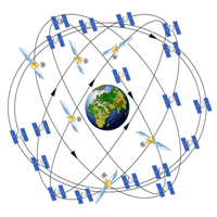
The 3 Global Navigation Satellite Systems that allow determining our position, our velocity and the time whenever and wherever on the Earth surface or within its neighborhood (low Earth satellite orbits). The precision of the position depends on the way it is computed and on the quality of the GNSS receiver. It can reach the level of 10 cm up to 10 m in real time, and up to some millimeters in post-processing. Different satellites systems exist or are presently in development, there are all explained here below : GPS, GLONASS, Galileo, COMPASS. When all the currently planned GNSS systems will be deployed, the users will benefit from the use of a total constellation of 75+ satellites, which will significantly improve the precision of positioning, and especially in the so-called "urban canyons" compared to GPS-only.
2. GPS
The first experimental Block I GPS satellite was launched in 1978 and GPS Full Operational Capability (FOC) was declared in July 1995. FOC status means that the system meets all the requirements specified in a variety of formal performance and requirements documents. While GPS is now used over the whole world, it was originally developed by the US army and is still monitored by the U.S. Department of Defense (DoD). However, today, GPS is managed by the National Space-Based Positioning, Navigation, and Timing (PNT) Executive Committee.
2.1 GPS Constellation
- About 30 satellites at an altitude of about 20200 km, distributed among 6 orbital planes of which the inclination with respect to the equator is 55°. With this constellation, one can always see 4 satellites minimum from any point on the Earth.
- Different generations of GPS satellites exist:
Block I (no more operational): Satellites launched between 1978 and 1985.
Block II and IIa: Launched after 1985, able to degrade the signals, lifetime 7,5 yr.
Block IIR: Launched after 1996, lifetime 10 yr. Able to communicate between them.
Block IIR-M: launched since 2005, transmit a second civil signal L2C on the L2 frequency and the military M signal on the L1 and L2 frequencies.
Block IIF: with new L5 civil signal
Block III: (first launch scheduled for 2014) new L1C civil code. - The revolution period of the satellites on their orbit is ½ sideral day (11h58).
2.2 GPS Signals
The GPS signals are transmitted on 2 frequencies, called L1 (1575.42 MHz) and L2 (1227.6 MHz), so that a combination of the signals can be used to cancel the ionospheric delays on the signals (more details in the Tutorial on the Ionosphere). These carriers are generated from the atomic clocks onboard the satellites. The two carriers are modulated by two PRN (Pseudo Random Noise) codes: the C/A(Coarse Acquisition)-code and the P(Precise)-code. The position of the satellites is broadcast as an additional modulation of the carriers (navigation message).
GPS provides two levels of service, the Standard Positioning Service and the Precise Positioning Service:
- The Standard Positioning Service (SPS) is a positioning and timing service which is available to all GPS users on a continuous, worldwide basis with no direct charge. SPS is provided on the GPS L1 frequency using the C/A-code and the broadcasted navigation message. In 2009, SPS provides a predictable positioning accuracy of 13 meters in horizontal (95%) and 22 meters in vertical (95%), and 40 ns for time (95%).
- The Precise Positioning Service (PPS) is a highly accurate military positioning, velocity and timing service which is available on a continuous, worldwide basis to users authorized by the U.S. The use of P(Y) code provides a predictable positioning accuracy of at least 60 cm (95 percent) horizontally and 80 cm vertically and time transfer accuracy to UTC within 40 ns. The P(Y) code is transmitted on both the GPS L1 and L2 frequencies. PPS was originally designed primarily for U.S. military use, but can now be used with a good accuracy by some high precision receivers.
2.3 Modernization of GPS
The GPS modernization involves new ground stations and new satellites, with additional navigation signals
for both civilian and military users, and aims to improve the GPS accuracy and availability for all users.
The new signals are:
3. GLONASS
GLONASS is an abbreviation for Global Navigation Satellite System, a GNSS system currently operated by the Russian Defense Ministry . The program was first started by the former Soviet Union, and is today under the auspices of the Commonwealth of Independent States (CIS). The first three test-satellites were launched into orbit on October 12, 1982. The GLONASS constellation was completed in 1995 (FOC). However, following completition, the system degraded with the collapse of the Russion economy. Beginning 2001, Russia commited to restore the system.
3.1 GLONASS Constellation
- 21 satellites (+ 3 active spares) at a altitude of 19,100 km,
- satellites distributed over 3 orbital planes (8 satellites per plane) of which the inclination with respect to equator is 64,8°,
- satellites at a 19,100km altitude,
- the revolution period of the satellites is 11h16.
The completed GLONASS system will require 24 functional satellites. In 2009, 17 satellites are operational and 10 additional satellites should be launched in the period 2009-2010.
3.2 GLONASS Signals
Similar to GPS, each GLONASS satellite transmits two codes (C/A and P-code) on two frequencies (L1 and L2 frequency) allowing again to remove the first order ionospheric error from the signals. However, while for GPS, each satellite transmits the same codes, this is not the case for GLONASS. GLONASS satellites emmit their signal each at different frequencies. The mean frequency for L1 is in the vicinity of 1602MHz (between 1597 and 1617MHz) and for L2 it is 1246 MHz (between 1240 and 1260MHz). These assigned frequencies should be changed in the course of the next years.
3.3 Modernization of GLONASS
In order to increase the performances of the positioning with GLONASS, new satellite and signals will be delivered within the next few years. In particular, GLONASS-K satellite will provide a third carrier frequency, G3, at 1024.704 Mhz with at least two signal modulations.
4. Galileo
On December 28, 2005 the first Galileo satellite was brought into orbit, with the designation GIOVE-A. Galileo is the European GNSS system. It should be fully operational in 2013. It is developed by the European Union (EU), in close cooperation with the European Space Agency (ESA).
The main goals of Galileo are to attain independence from the USA, to increase the accuracy of positioning, and to have a purely civilian navigation system.
Galileo will provide different services:
- Open Service (OS) is foreseen for mass-market applications. It provides free signals on L1, so that navigation receivers will be able to combine the signals of GPS+Galileo for the determination of position and time.
- Commercial Service (CS) is envisaged for market applications with higher performance demands than the OS. CS is designed to provide a variety of beneficial services to its customers on a fee for usage basis. Typical examples of these applications would be services providing high-speed data transmission, guarantees of availability, exact-time related services, as well as local correction signals for maximal in positioning accuracy.
- Safety of Life Service (SoL) is envisaged primarily for transportation applications (maritime navigation, aviation and rail traffic) for which an impairment of the navigation system without adequate warning could result in a life-threatening situation. This service provides worldwide high level of information integrity.
- Public Regulated Service (PRS) will be available to such clients as police and fire departments and border patrols. Access to this service is restricted and controlled by a civilian agency.
- Search and Rescue (SAR) will be used by humanitarian search and rescue services. Emergency transmitters and satellites enable the location of individual persons, crafts and vehicles in aviation, land and maritime emergencies to within meters.
4.1 Galileo Constellation
Galileo will consist of a constellation of 30 satellites on 3 circular orbital planes at an altitude
of 23,616 km above the Earth.
4 satellites should be launched in 2010 for the In Orbit Validation (IOV) phase.
4.2 Galileo Signals
Galileo should be as interoperable as possible with the existing systems. For this reason, the Galileo frequencies will be equivalent to the present and future GPS/GLONASS frequencies : E1 (1575.42 Mhz), E5a (1176.45 Mhz) and E5b (1207.14 Mhz); additionally, Galileo will use E6 (1278.75 Mhz) for special services.
5. COMPASS
China is also developing an independent GNSS, called COMPASS. This new system will consist of a constellation of 35 satellites, which include 5 geostationary orbit
(GEO) satellites and 30 medium Earth orbit (MEO) satellites.
Presently (2009), 4 LEO and one MEO satellites (called Beidou) have been launched.
COMPASS will broadcast on at least 3 frequency bands, namely 1207.14 Mhz (close to Galileo E5b),
1268.52 Mhz (close to Galileo E6), and 1561.2 Mhz (close to Galileo E1).
Similarly to the other GNSS, there will be two levels of positioning service: open and
restricted (military).
6. Satellite Based Augmentation Systems
The Satellite Based Augmentation System (SBAS) are regional augmentation systems through the use of additional satellite-broadcast messages. Such systems are commonly composed of multiple ground stations, located at accurately-surveyed points. The ground stations take measurements of the GNSS satellites, and environmental factors which may impact the signal received by the users. Using these measurements, information messages are created and sent to one or more satellites for broadcast to the end users. As an example, these messages inform the users about GNSS satellites that should not be used because their signals are bad and would give to the user a wrong position, or provide to the users an ionospheric and satellite clock corrections more precise than the corrections broadcast in the navigation message.
Examples:
- WAAS is developed by the U.S. Federal Aviation Administration for aircraft traffic control, in order to help the aviation to make their GPS navigation even more accurate and hence reduce the risk of crash.
- WAGE (Wide Area GPS Enhancement) is the equivalent systems, developed by the US department of Defense, only for P(Y) code users.
- EGNOS (European Geostationary Navigation Overlay Service) is the similar system for Europe,
- GAGAN (GPS Aided Geo Augmented Navigation) is in construction for India, and
- QZSS (Quasi-Zenith Satellite System) is developed by Japan.